Saturday, January 22, 2022

The Turquoise Trail


There are many ways to get where you want to go in life. Sometimes that statement is metaphorical, perhaps alluding to life's journey between childhood and adulthood and happiness and whatever else there is in life. Sometimes it is literal, meaning there are actually multiple ways to get from point A to point B on our planet. This post deals with the latter, although I'm sure it touches a little bit on the former.

The most direct drive from Albuquerque to Santa Fe in New Mexico takes about an hour, depending on how fast you think you can drive and not get pulled over on I-40. Seriously. It's a bit more than 60 miles and it really is a very quick trip on the interstate. It's efficient, it's effective, it's everything our country's interstate system was designed to be. But if you have an extra half hour to spare, there's a more scenic route which takes you over and around some of New Mexico's mountains, down old Route 66 and through some towns that time had once forgotten (literally). Sometimes you gotta take the scenic route in life. Sometimes it's worth it.

OK, maybe if you want to do it right, it's a quite a bit more than 30 minutes longer. 

I am sure there are innumerable ways to get from Albuquerque to Santa Fe. But if you want to go fairly directly and definitely not on I-40, I'd suggest you take the way through the towns of Cedar Crest, Sandia Park, Golden, Madrid and Cerrillos. Otherwise known as the Turquoise Trail. And yes, and perhaps completely obviously, turquoise was once mined in the part of our country traversed by the road. 

We had a plan (we ALWAYS have a plan) for the Turquoise Trail. An early start from Albuquerque, a couple of stops in Cedar Crest, Sandia Park and Golden and then onto what we believed would be the stars of this drive: Madrid (pronounced MAD-rid) and Cerrillos. I love a good plan. 


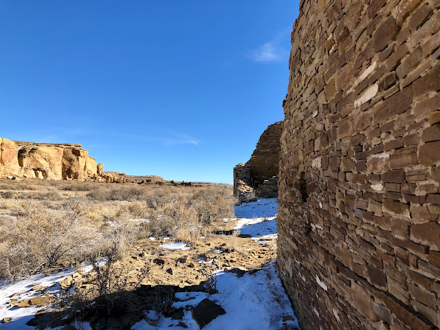
The scenic route between ABQ and Santa Fe (top) and yes, there was mining happening. Maybe turquoise, maybe gold.
So first of all here, let me say that COVID sucks. I know, we all know that. For whatever reason (and it's not always the same reason) most people on Earth probably believe that. But I'll also say that (and I'm completely assigning blame here without really researching who's responsible for my anger on this issue) the New Mexico Department of Transportation also sucks. And both of those things or agencies messed up our scenic trip from Albuquerque to Santa Fe. 

The key to our timing everything just perfectly on the Turquoise Trail was spending a little time at the Tijeras Pueblo Archaeological Site near Cedar Crest and then stopping at the legendary Henderson Store in Golden browsing and possibly buying some native American jewelry. That would get us late enough in the morning that everything in Madrid and Cerrillos that we wanted to see would be open when we got there. But the Archaeological Site was closed (it's on pueblo land; I assumed because Tijeras isn't one of the 19 New Mexican pueblos that the site would not be and I was wrong) because, well, you know...COVID. That messed all our timing up.

Before we got to the Tijeras Pueblo site, we had another stop to make: a rumble strip along the right side of the eastbound old Route 66 which, if driven over at precisely 45 miles per hour, would play "American The Beautiful" on our car's tires (or something like that). I have long had a drive all the way down Route 66 (or a reasonable facsimile of the Mother Road, anyway) on my wish list and have a number of sites like this to hit if I ever make the trip. Since we were going to be on the actual road anyway, this seemed like a can't miss opportunity.

However, it's not there anymore. Not really. Somebody or some thing (and here's where I blame NMDOT without really knowing if they are to blame) has paved over the musical rumble strip. Sure, I can see it being a dangerous situation with people like me driving down and then turning around and driving down a stretch of road in search of some small thrill but where's the whimsey in this world if people keep taking away this stuff?

I believe we did find the rumble strip and we did get a bit of a tune, but if it was more than 10 seconds long then my memory is severely faulty. Maybe they (I'm looking at you, NMDOT) left a little bit to give folks like me some sense of accomplishment.

Now, despite all those bumps in the road, our time on the Turquoise Trail was awesome. And it was all about Madrid and Cerrillos.


Llama, Cerrillos (top). Art galleries, Madrid (bottom).
There are many, many old mining towns in the American southwest that are long since abandoned, victims of rapid boomtown growth and equally rapid abandonment when the seams disappeared, whatever those seams happened to be holding that men felt like they had to extract at all costs. New Mexico is littered with these sorts of places. Most of them are now ghost towns in various states of decay or restoration or somewhere in between. Madrid was one of those ghost towns about eighty-some years ago. Now it is not.

Madrid was established in 1869. A few decades earlier, coal had been found in the area in addition to some small gold deposits. The town didn't attract much attention until the 1880s when the Santa Fe Railroad got close enough to the town to make all sorts of get rich quick schemers decide to try their hand at coal and gold mining. Eventually, business became big enough for the Albuquerque and Cerrillos Coal Company to move in and take over. That lasted until about the 1950s when the whole thing collapsed and the town should have died and faded to nothingness.

Only it didn't. In the 1970s, artists started moving into the old buildings left behind in the town's heyday and things just kept building from there. 50 years on, Madrid is a major art center in New Mexico alongside enough other curiosities to keep most anyone interested.

I love neighborhoods with a significant mass of art galleries. It's like having a series of almost world-class art museums with no admission charge where you can actually take the things home if you like what's hanging on the wall enough. That is if you can fork over the money to make whatever you have fallen in love with yours. And it's even better when the what you fall in love with is actually affordable. 

We didn't buy anything in Madrid, although we could have quite easily. But we did enjoy looking at what was on the walls of two or three of the galleries in town. We also enjoyed making our own kind of artwork at Connie's Photo Park, a series of plywood painted pictures with cutouts to accommodate your face (or more...like the cover picture of this post) in a variety of outrageous but totally New Mexico situations. The old Madrid jail, a cowboy riding a bison, an angry miner or just driving a classic car down old Route 66.


Madrid, NM.
And then there's Cerrillos.

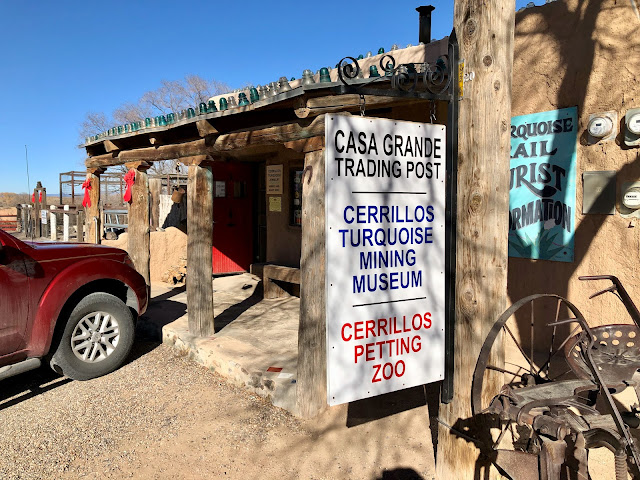
We made one stop in Cerrillos. At the Casa Grande Trading Post which also houses the Cerrillos Turquoise Mining Museum and the Cerrillos Petting Zoo. Hence the llama in the picture above. We did not feed the llama.

I'm not sure how exactly to put into words how amateur, cheesy, special and glorious the Casa Grande Trading Post (etc.) actually is. As the name suggests, it is part store ("Trading Post"), part museum (barely but sometimes yes, completely) and part zoo. I'm going to stop short of the "petting zoo" moniker because I'm not sure I want to pet llamas and all the birds are behind fencing with bars a small enough distance apart to preclude interaction between fowl and human almost completely. I guess if you have small enough fingers, but then again I might be worried about those being perceived as food. 

They do have some of the most incredible looking chickens, though. Seriously. These are some gorgeous birds. 


Inside the Trading Post, you will find just about anything and everything you could possibly hope to find to make life easier in the late 1800s or early 1900s. I'm not entirely joking. OK, so maybe there are some pieces of jewelry that you might actually want to wear today (there are...for real) next to the hunks of turquoise, antique foreign money and other curiosities. And yes, you can take all this home from the Trading Post although good luck trading anything but 21st century American cash for whatever you've picked out.

Walk to the back of the Trading Post (after paying your $5 admission) and you'll find the Cerrillos Turquoise Mining Museum. Honestly, there's not a lot of difference between what's in the Trading Post vs. what's in the Museum, although I guess really nothing is for sale in the Museum. There are some objects in the Museum that seem to have nothing to do with turquoise mining (the gold panner exhibit shown above comes to mind here) or even in some cases even mining of any sort (Big Mouth Billy Bass or map of the world with stamps on it, anyone?).

The best thing about the Casa Grande Trading Post (etc.) is that in walking around the place, there are some absolute gems. I don't mean precious rocks. I mean relics of history that those of us in 2021 or 2022 cannot maybe even conceive of them even existing in the first place. The building is peppered with these items and the opportunity to discover them is worth spending 20 or 30 minutes walking around the place and yes, even plunking down a five spot to make it all the way into the museum in the back.

What am I talking about here? How about multiple displays detailing the history and variants of barbed wire. Didn't know there was more than one kind? There are definitely more than 30 or 40 different types in both the Trading Post and the Museum. Not into barbed wire? Maybe you'll find the mining company tokens worth a look. These were issued as currency as part of the miners' wages for payment at the company store, where I'm sure the companies indentured their workers through overpriced merchandise as effectively as former plantation owners did with freed slaves as sharecroppers following the Civil War.

No takers there? I am confident there is something for everyone to marvel at in this store. And really...when do we really do a lot of marveling these days? Any place that offers that has to be worth a few minutes of time. One of my favorite items in the store for sale was the railroad date nails which were used to install railroad ties. The nails were stamped with the last two digits of the year they were hammered into place. I guess so you can keep track of how old your nails are. I thought about bringing back a "68" nail (I was born in 1968) but then thought better of it. I mean, what would I really do with it?


I'm not being the least bit facetious in my words about the Casa Grande Trading Post. I really mean that it's both full of junk AND has some of the most amazing artifacts I've seen in years. I am confident that most reasonably curious people will wander into the place and find something completely fascinating. These places don't exist in too many spots in the United States. They are worth stopping at when the opportunity is there. But...only if you take the scenic route when you are traveling between Albuquerque and Santa Fe

I loved our time on the Turquoise Trail but I also feel we have unfinished business there. We missed the Tijeras Pueblo Archaeological Trail and Henderson Store completely and we didn't buy any art in Madrid (probably because we bought enough in Albuquerque and Santa Fe before we got to the Trail). We did find the best green chile cheeseburger of the trip (an essential New Mexico meal) at the Mine Shaft Tavern in Madrid and we'd definitely I think go back there on a return trip down the Turquoise Trail.

And who's kidding whom...it would be difficult to not stop at the Casa Grande. It has to be different every time out.

Mine Shaft Tavern, Madrid. Best green chile cheeseburger of the trip.


How We Did It

Under normal (non-COVID) circumstances, the Tijeras Pueblo Archaeological Site is open dawn to dusk. There's apparently a museum on site which is allegedly open on weekends, but probably not until this pandemic goes away.

The truly excellent Casa Grande Trading Post / Cerrillos Turquoise Mining Museum / Cerrillos Petting Zoo is open 10 a.m. to 4 p.m. "most days and weekends" according to their website. We got there on a weekday right at 10 in the morning and found the place closed. But hanging around for five minutes or so was enough time to wait for the place to open up. And it's soooo worth it.

Connie's Photo Park in Madrid is open 24 hours a day, although I imagine it's way more fun in the light than in the dark. There's a collection box to the right of the entrance to the Park. Why wouldn't you chip in a couple of bucks or maybe a little bit more for the memories you'll walk away from this place with.

The Mine Shaft Tavern in Madrid is open daily at 11:30 a.m. Most days they close up at 8 p.m. but on Fridays and Saturdays they cut loose and add another hour to closing time. There's a stage in the place that I'm sure hasn't been used regularly for a couple of years. I'd go back here any time. Their food was awesome and they had a great tap list (I highly recommend Second Street Brewery's Porter if they have it). The graffiti in the bathroom made me feel at home also. No more to be said on that last point but it's comforting to find a place that clearly leans the way I do. Maybe one day we can see some music here on a future trip. And there will be future trips if I have any say in it.


Friday, January 14, 2022

Chaco Canyon

Our December trip to New Mexico was not my first trip to the Land of Enchantment. We visited the southern part of that state in early 2017 and I took a solo trip there way back in 2001. The variety and complexity of the landscape and history and culture of that state is just incredible. It's amazing it's not full of tourist but it seemed from everyone I talked to about this trip that New Mexico is off the radar of most people. It's like there's Texas then Arizona and then California. I don't understand it. But I'm also happy for it to be tourist-free.

My 2001 trip to New Mexico has to have included one of the all-time schedule blunders in my vacation planning history. I don't have many, but sometimes when I blow a schedule, I blow it spectacularly. On that trip, I drove down from Denver to spend three or four nights in Santa Fe before heading back to the mile high city and beyond into Wyoming. I planned to spend one of my days in New Mexico driving to Mesa Verde in southwest Colorado with maybe a stop at either Aztec Ruins National Monument or Chaco Culture National Historical Park on the way back. 

The whole idea of that day trip itinerary is preposterous. Santa Fe is not anywhere close to Mesa Verde. How I didn't realize that those two spots are 4-1/2 hours apart by car is beyond me. There was absolutely no way I could possible have driven to Mesa Verde and back and stopped at any other spot, even without construction on the way there that restricted the road I was driving on to a single lane stuck behind a slow-moving truck. If I'm remembering right, this was one of those leave at 6 a.m. and get back at about midnight days that I occasionally used to spend on my trips around the United States. 

I've rued that day ever since. Not so much for Aztec Ruins, but for sure for Chaco Culture. When we decided on New Mexico as our December 2021 getaway, Chaco Culture was at the top of my list. 20+ years is a long time to be rueing. I wanted to stop the rue-age.

Looking east towards Pueblo Bonito from Pueblo del Arroyo.

I would imagine that most people have never heard of Chaco Culture National Historical Park. Part of that may be that it's in New Mexico and therefore out of most people's ideas of what a vacation in the United States might look like. Part of it might be that it tells the story of an indigenous peoples' settlement prior to the arrival of Europeans in the New World. And part of it might be that it's just absolutely in the middle of nowhere. In fact, that last part is probably the biggest deterrent. 

I thought I had been to some National Park Service properties that were in the middle of nowhere before visiting Chaco Culture but the reality of the situation is I had not. I thought we had gotten ourselves pretty remote from civilization just a day before we visited Chaco Culture by checking out the Gran Quivira portion of the Salinas Pueblo Missions National Monument and in June of 2020 when we made the trip to Hovenweep National Monument in southeast Utah. I was wrong.

Driving to Chaco Culture from Albuquerque seems like a reasonable enough proposition. It's only 155 miles and Google Maps says you can get there in just a bit less than 2 hours and 45 minutes. Take I-25 north for a bit before exiting at Bernalillo and then spending a lot of time on Route 550 before hanging a left on New Mexico Road 7900. Take a right off 7900 onto 7950 and eventually the road will disappear. 

I don't really mean that the road disappears. More like the paving disappears. Now, lest you think I'm some citified idiot who's never driven on a dirt road before, I've spent my fair share of driving on unpaved roads in my time, let me tell you. I used to take dirt roads to work in upstate New York in winter specifically because they weren't as icy as the paved roads. I know dirt roads. 


The back wall of Chetro Ketl and a doorway with remains of floor beams above in Pueblo Bonito. 

But I've never driven on anything like the roads to Chaco Culture. When the paving ends there's a 12 to 13 mile section of dirt road that I'd categorize as your standard dirt road that you can comfortably drive 30 miles per hour or so with maybe some spots where you need to slow down a bit or find the best surface by driving on the wrong side of the road every now and then. Hey...it's not like there's anyone coming the other way. We might have passed one car coming the other way coming and going from Chaco Culture.

That's not the tough stretch. After those 12 to 13 miles there's a final stretch of non-paved road that's about three or four miles long and it's a 15 miles per hour maximum road with most parts at 10 miles per hour. The road is so rough that if you go too fast, it feels like the entire car is going to be shaken apart. Four miles at 10 miles per hour takes a long time. Keep in mind, this is after you've dropped cell service a while ago and you haven't seen another car either going your way or the other way likely for a good bit of time too. Anything happens to your car out there and you are not in a good spot. This place is super remote. I'm sure it deters visitors. A lot.

Then you reach the Park gate and everything's paved. It's crazy. Chaco Culture gets between thirty-some and fifty-some thousand visitors per year (although in 2020 when they closed the Park for a bit, they drew just 8,321 visitors). As a comparison, Great Smoky Mountain National Park hasn't drawn less than 10 million visitors in a year since 2014.

Chaco Canyon, from Casa Rinconada Community looking west to Pueblo Bonito and Pueblo del Arroyo.

OK, so it's remote. I think I've established that. What's the payoff? Why go? Just so you can say you have been somewhere remote? 

Not remotely.

Before Europeans "found" the New World, before the native American pueblos that still exist in New Mexico today were established, there was a thriving civilization centered around what today is the "four corners" of New Mexico, Colorado, Utah and Arizona. The ruins that can still be found at Mesa Verde National Park and Hovenweep National Monument were part of that civilization that existed at that time. We are talking serious large sites that were agricultural in nature and had time for things like religion and the arts. Sophisticated peoples. We are also talking like 1,000 to 1,300 years ago. Not recent history.

Of all the sites of this period, the largest by far is at Chaco Canyon. I knew that before I got here. I knew this was a fairly large canyon that had multiple, multi-family dwellings (for lack of a better term pre-visit) constructed within it. Given that size and scale, it seemed it was probably worth the drive into the middle of nowhere and over roads that shook most bolts and rivets on our rental car loose just a little bit.

I had no idea.

Window opening at Pueblo Bonito (top). Stonework at Casa Rinconada Community (bottom).

A visit to Chaco Culture National Historical Park starts at the Visitor Center. I've been to many, many National Park Service properties and have stopped at or skipped (as I believe is appropriate) the visitor center. At Chaco Culture, it's mandatory because they want to know who is there so nobody gets left behind at the end of the day. I'm not kidding. They do a sweep of the road to make sure all cars are gone by closing time. Don't want anyone stuck in the desert overnight.

After our paid admission (free thanks to our National Park Annual Pass), we were told our visit to Chaco Canyon would likely be a minimum of four hours, one hour each at the main stops of Pueblo Bonito, Chetro Ketl, Pueblo del Arroyo and Casa Rinconada Community. They are joking, right? There's no way we are spending four hours in the middle of the desert within days of the shortest day of the year looking at ancient ruins. I mean, they can't be that big, I'm sure.

I was wrong. I had no idea how big these things are. Multi-family dwellings I was thinking. Umm...no. Not exactly. How about large scale condominiums. 


Pueblo Bonito.
Chaco Canyon was not the only spot in New Mexico we visited with hundreds of years old pueblo ruins in our week in December out west. We stopped at Pecos National Historical Park and the three-site Salinas Pueblo Missions National Monument in the couple of days before we made our way out into the desert via those dirt roads. Both Pecos and Salinas Pueblo boasted that their pueblos in their glory days would extend three or four stories high and then left the rest to your imagination based on the foundation ruins barely poking out of the soil. It was honestly difficult to imagine such a thing and the line drawings depicting what life might have been like in the 1600s didn't really help much.

At Chaco Canyon, we didn't have to imagine because those multi-story structures described at the other sites were right there in front of us in real life. Still standing. After more than 1,000 years. It's one thing to read about it on a sign. It's another thing entirely to walk around, above and through it. There's no imagining needed at Chaco Canyon. It's all right there. The impression is honestly staggering. These ruins are huge and incredibly intact. I mentioned earlier visiting Mesa Verde and Hovenweep as contemporary sites to Chaco Canyon. They are nowhere near as massive as this place. As gorgeous as Mesa Verde is with all those ancient dwellings under the cliff edges, Chaco Culture blows it away.

It's the scale more than anything else. I mentioned large scale condominiums tongue-in-cheek as modern comparisons a few paragraphs ago. I wasn't kidding. I see a large dwelling complex with four of five story housing blocks on the outside and two massive interior courtyards with community-use kivas (large underground circular religious spaces) and I think of the condo building I used to live in with 21 stories of residential units and a gym and pool on the roof and shared green space on the ground floor. It's not a far-fetched comparison.


View of the plazas (top) and the great kiva (bottom) at Pueblo Bonito.
We spent the most time at Pueblo Bonito, the largest and most intact of the many communal dwelling structures on the site. And the guidance we received at the Visitor Center was probably right - we did spend about an hour at this property. The four stops we were advised to visit during our orientation talk (and we did visit all four), by the way, are not the only four ruins on the site. They are just the four most easily accessible by car. If you wanted to do a bit of hiking (between about a mile and three miles each way), there are other ruins in the canyon. The overall impression is large scale building after large scale building stretching out for miles. The scale is stunning. The atmosphere in the Canyon in its heyday, with people moving between all the stops in the community must have been impressive, particularly because the Canyon itself would have been far, far greener.

Pueblo Bonito likely dates back to the middle of the 800s at a time when Europe (I know, I shouldn't be bringing up Europe here) was mired in the dark ages. It is D-shaped in plan with thin layer of residential rooms around the exterior perimeter and the public rooms (mostly kivas - about 30!!) and large open spaces inside the complex. It is mostly, but not completely, excavated with a lot of the stone walls still intact, along with some of the wooden floor and roof structural members as well as a lot of the window and door openings. Amazing to think that wood has survived intact for over a millennium, most likely a product of being left out in a place with about zero moisture most months of the year.

One of the best parts about visiting Pueblo Bonito is that you can walk through the rooms. As delicate and fragile as the old walls are, there are no roped off sections of the ruin. Have at it. Go wherever you like. Just be careful of where you step for your own protection and that of the ages old masonry. It is actually such a privilege to be trusted to walk through a place like this. We walked through openings as low as four feet and it is difficult to walk through openings that small without touching the walls themselves.

Walking through is essential. You get a feeling of how someone living here might have moved through the structure. You also get a sense of how compact the floor to floor height was back in the day by measuring the top of your head against the still intact floor beams that still show up in a lot of spots. There would not have been a lot of space for someone close to six feet in height. For sure there would have been a lot of stooping or head-knocking (or both) for me, but I'm also supposing there were not many people my height living there.

Ruined wall at Pueblo Bonito showing the core and veneer in the wall construction.
You can also get a great understanding of how the place was built by walking through Pueblo Bonito. Now admittedly, most of this understanding comes from looking at half collapsed walls. The exterior of the walls were built with a regular veneer consisting of bands of large and small stones facing an irregular core that was built strictly for structural purposes. But there are also parts of Pueblo Bonito where the original floor construction was discovered intact (and likely buried in sand) that can been seen inside heavily rain-protected structures on site. It's informative, but not very visible.

For a better look at how the structure of the floors were built, I'd recommend exploring Pueblo del Arroyo, the next stop along the one way driving loop after the Visitor Center. There are two spots at that site that show this off really well and both are shown below. The traditional way of laying flooring in Chaco Canyon involved three layers: a series of heavy beams seen in most structures that we walked through, topped by a series of lighter spanning members before the flooring itself was laid on top. Incredibly there's one spot you can look down on all three layers of structure at Pueblo del Arroyo. 

A little later in the tour route, there's another spot with a series of broken heavy beams set about two feet above a layer of sand, obviously filling in a room because there's a sliver of door opening in the rear of that chamber. It's amazing how slowly things break down in the desert. These splintered wood members have probably been there in that spot for 1,000 years. 


It is likely impossible to cover all of Chaco Culture National Historical Park in a day. Not properly. And then not even on the longest day of the year. We visited close to the shortest day of the year and our relatively late arrival time combined with thoughts of getting out of the Park at a reasonable time and having to drive on that car-shaking road again had us leaving after a couple of hours. I feel we did Pueblo Bonito and Pueblo del Arroyo really thoroughly. We also walked from Pueblo Bonito east to Chetro Ketl on the petroglyph route and spent some time checking out the largest excavated kiva on the site at Casa Rinconada.

Casa Rinconada is a useful stop because it is not like the larger group houses like Pueblo Bonito. If Pueblo Bonito struck me as a sort of an ancient condominium, Casa Rinconada resembled a suburban neighborhood, with individual dwellings dotting the canyon adjacent a super-sized community kiva. Maybe I'm all wrong with my characterization of the site based on 20th / 21st century comparisons of how we live now, but that's how the place struck me.

I do think that we saw enough to get a really good impression of what the Canyon might have looked like back in the day and I don't know quite what exploring more would have got us. The incredible part about this whole site is that the seven or eight different parts of the Canyon that are open for visitation are that way because they have been excavated. There are likely many more ruins still out there. We can't possibly have the full picture of how significant this settlement was at one time.

I know I wrote this same thought in my Hovenweep post about 18 months or so ago but whenever I visit sites like this, particularly from a culture with no written historical record, I am struck by what the builders of this place might think about me wondering around what they erected with their hands all that time ago. I'm an architect and I've designed buildings that are maybe going to be around for a century or more and that might be on the very long end of their lifespans. The people that built in Chaco Canyon put stones together to make walls and wooden logs to make floors that have stood for maybe 1,200 years or more. And with no maintenance or real preservation (except being buried in sand). That is an extraordinary achievement. I'd love to know that something I created had that level of permanence.


The great kiva at Casa Rinconada (top) and a wall at Pueblo del Arroyo (bottom).

While the buildings they made might have lasted, human habitation in Chaco Canyon did not. In around the 1200s, drought hit the area and it was prolonged enough that it forced those who had created this grand community to leave. It's not difficult to imagine a prolonged drought in Chaco Canyon today. It's literally a desert. I don't know for sure, but when I use the term prolonged it might actually mean from the 1200s until today.

If I'm remembering correctly, when I did a little research about this place in 2001, the conventional wisdom about the people who built Pueblo Bonito and the other great houses was that they were a people called the Anasazi, who had one day just picked up and left what is now the "four corners" area and had mysteriously disappeared, although the Anasazi name was beginning to be removed from descriptions about sites in the area back in 2001. Now, the narrative is that the people who built Chaco Canyon moved south or south and east and became the Zuni, the Hopi and the peoples who built the series of pueblos along the Rio Grande. That explanation makes way more sense than a whole civilization just vanishing mysteriously. I can't imagine how that theory came together.

Our visit to Chaco Culture filled in a huge gap in my personal historical record. It shattered my impression of native American settlements being small communities like I'd seen at Hovenweep and Mesa Verde (I know there's a lot more at Mesa Verde than at Hovenweep but it's nowhere close to the scale of Chaco Canyon). It also put form to what we'd read on signs on this trip and past trips. No longer do I have to imagine what the scale of one of these communities might look like. I've walked through it.

I'm blessed with a reasonably good memory and despite all the years I've been traveling this century, I never forgot that I needed to make it to Chaco Culture someday. It was way different and way better than I ever thought it would be. This is an astonishing place, even with that drive in over the last three or four miles. I'm also glad we went in winter and that, despite the near freezing temperatures, it was a gorgeous day. It's not difficult to get gorgeous blue skies in a place as dry as New Mexico but I think the pictures we took this day turned out great, right down to the snow on the ground.

Last look at Pueblo Bonito in the distance (from Chetro Ketl).


How We Did It

Chaco Culture National Historical Monument is open pretty much daily. When we visited the Visitor Center was open from 9 a.m. to 5 p.m. and the loop road that accesses the ruins was open from 7 a.m. to 5 p.m. with the last admission to the road by 4:30 p.m. All cars are cleared out at 5 p.m. so I'm not sure why you would enter the loop road that late. You can't possibly just be "in the area". I'm not sure if hours vary by season. Check the Park's website for that information. 

It's worth noting that there is no restaurant in the Park. Bring food if you will be getting hungry for a snack or a meal. It's a long way back out to get some. There's also no fuel in the Park. Make sure you have enough juice to get there and back. There's no gas stations once you get off Route 550.

It's also the desert. Bring water. 


Saturday, January 8, 2022

Spanish Ruins


I like to think of myself as fairly well-traveled and worldly. It's arrogant, I know, but there are some good reasons I think of myself this way: I've set foot on six of the seven (or eight, depending on who you believe or choose to believe) continents on our planet; I was born in one continent and live in another; and I've made a point of learning about the history and culture of the places I've traveled when I set foot away from home. I don't just go to the tourist-y parts of wherever I'm headed. I seek out the "real" experiences. This all makes me feel somewhat superior. It's obnoxious and egomaniacal but sometimes I feel this way.

Then every so often, something happens that yanks me back to reality and reminds me that I'm not that special after all and that I carry just as many biases that distort my worldview as most every other person on the planet. That "something" happened again last month when we were in New Mexico.

So, I'll admit it: my view of the history of the settlement of the United States is sometimes lazy. I don't mean the fact that there were people here before European people arrived here for good in the late 1400s. I get that there have been indigenous people in North and South America for thousands of years and that they were as diverse as the landscape of the New World (there I go again convincing myself I'm worldly...).

No. My lazy and very east coast view of the settlement of our country (and I can't believe I'm going to write this) is that Europeans landed on the eastern shore of what would later become the United States and settled generally westward. Yes, I know that there were missionaries and Californios out on the west coast before the USA claimed all the territory between the Atlantic and Pacific Oceans south of Canada and north of Mexico. But it's not like it's pre-Revolutionary War type history or anything like that, right? Right?

By the way, that part about the "real" experiences on my travels. I'm sure I'm kidding myself about that too.

The remains of the Spanish mission church at Quarai. Construction started in 1627.
St. Augustine, Florida was founded in 1565. It is the oldest, continuously-inhabited, European-established settlement in the United States. The Roanoke Colony, the first permanent English settlement in the new world, was founded in 1585 in what is now North Carolina. And how about those pilgrims at Plymouth Rock. They famously landed on these shores in Massachusetts in 1620. And from there, everything spread west, right? 13 colonies, Declaration of Independence, Revolutionary War, Louisiana Purchase, Mexican-American War, Manifest Destiny, Alaska, Hawaii. Isn't that the history of the settlement of our country, in pretty much that order?

It is not. Spanish conquistadors explored what is now New Mexico in 1541. 1541!!!! The first Spanish settlement in our 47th state was founded in 1598. Santa Fe was established in 1610. Europeans have been in New Mexico almost 500 years. Before St. Augustine. Before the Roanoke Colony. Before Plymouth Rock. They came. They built. They brought disease, destruction, death and enslavement. And they left ruins. We thought it might be worthwhile traveling into the New Mexico desert to find some of them.

The second church at Gran Quivira. Construction started in 1659.

Maybe a few words about the Spanish colonization of the New World are in order.

The Spanish were not complicated explorers when it came to the settlement of the Western Hemisphere. Their objectives were fairly simple: (1) convert any indigenous people they encountered to Catholicism and (2) find treasure. Lots of treasure. And if it appeared that there was no treasure or the locals weren't giving up its location, they weren't above some pretty harsh measures. Nor, in some cases, were the priests who were bringing religion to the natives when Jesus didn't take. Not that the natives weren't religious (they were) but they weren't the RIGHT religion in the view of the Spanish Crown.

To spread religion (and kill and rob those possessing the treasure), the Spanish sent two kinds of people into the future New Mexico wilderness: priests and soldiers. Sending soldiers into foreign lands was a tried and true model for the Spanish. It worked with the Aztecs and it worked with the Incas. The Aztecs had tons of gold. The Incas had tons of gold. Their forays into New Mexico would just tweak that model a bit. But surely, all indigenous people in the New World had tons of gold. And they would get the added bonus of the Spanish bringing God with them. No, no, not the existing gods. The REAL God.

The remains of the mission church at Abó, completed in 1651.

What the Spanish found when they started exploring New Mexico was (for the most part) a settled, agricultural society (without gold). They found people living in towns (the Spanish called them pueblos) three, four and five stories high and farming, hunting and collectively pitching in to make the whole thing work. Pottery, cooking, artwork, clothes making, trading, whatever was required to make the entire operation run smoothly. So the Spanish did the only thing that made sense to them: they settled right next to the pueblos. After all, if you wanted to convert people to your religion, you needed to be near to the people you wanted to convert.

I'm not going to lionize the Spanish priests sent into the wilderness in the New World because, God knows (and yes, there's some irony there) they were often unnecessarily cruel in their dealings with native populations. But I will say (and this is with or without soldiers) that the prospect of being sent into a completely alien land where you might meet hostile people willing to kill you at a moment's notice would have terrified me.

And I have to say, the landscapes these priests and soldiers traveled through and over 400 years ago can't look that much different than where we drove last month. The New Mexico desert, stretching for as far as the eye can see dotted with piñon and juniper and yucca and terminating in mesas and mountains, is both extremely gorgeous and completely remote. The first time I drove through New Mexico in 2001 I thought it would be easy to understand what the landscape looked like before the arrival of man because all you would have to do is remove the one road I was traveling on. I felt the same way last month.

Our quest for Spanish ruins in the New Mexico desert (because that's exactly what it boiled down to) centered around two National Park Service properties: the three-site Salinas Pueblo Missions National Monument south of Albuquerque and Pecos National Historical Park south and east of Santa Fe. There is value in visiting both properties.

A rough ride down New Mexico 41.

There is also great value in actually getting there. The New Mexico desert is for sure (and I realize I just said this) a place to behold. The amount of nothingness set against sky is stunning. They call Montana the big sky country. I've been to Montana and I'll take New Mexico's sky over that of Montana any day. One of the most extraordinary hours we spent in New Mexico last month was a 50 minute or so drive southbound down New Mexico 41 in the direction of Salinas Pueblo Missions dodging and mostly hitting hundreds of tumbleweeds rolling across the road in the desert wind. And I'm not exaggerating with the hundreds. There were continuous tumbleweeds rolling across the road for the better part of an hour.

Salinas Pueblo Missions National Monument consists of three sites that the Spanish visited and settled in the 1600s. The three parts of the Park (Gran Quivira, Quarai and Abò) are centered around the town of Mountainair, NM. I guess it's the closest town that's about equidistant between the three sites and it's pretty much in the middle of nowhere. There's one stop light and a series of storefronts (not all open for business) on one side of the street that can't be more than a quarter of a mile long. Just west of Mountainair there are a series of salt lakes (las salinas - and hence the name of the National Monument) which at one time would have represented a source of some wealth, particularly interior to the nation. Easier to extract the salt from somewhere close than travel to the Pacific Ocean or the Gulf of Mexico.

A couple of notes about the Park. First, Gran Quivira is remote. Like really, really remote. There was nobody else there when we arrived and that remained the same throughout our visit. No rangers, no visitors, no cell phone service, no nothing, although the bathroom was thankfully open. It's been a while since I've been that far out into nothingness (although that experience would get surpassed like the very next day). However, as a place to learn about the Spanish and the native pueblos already there before the Spanish, I found it lacking. There clearly at one time was a significantly sized settlement here but today, it's mostly a series of low foundations and a ruined church made from stone that's as pale (but just a bit whiter) than the grass in the surrounding desert.

I felt similarly about Quarai. The church at that site is a lot more intact but the property sits in a hollow which tends to divorce the site from the desert a little. One of the ideas I wanted to explore was that the hand of man and the ruins long left behind could actually enhance the beauty of the desert by highlighting the natural beauty of the landscape against something non-natural. I didn't get that sense at either Gran Quivira or Quarai.


Abó, with the old church fragments in the foreground and the Mazano Mountains behind.
But if there's a bit of a letdown in the sites at Gran Quivira and Quarai, there is a great payoff at Abó. All three sites were abandoned in the 1660s or 1670s, likely due to drought and raids from the neighboring Apache people. When the natives (and the Spanish) fled Gran Quivira and Quarai, most of them came to Abó, only to leave that site about 10 years later.

The church at Abó, while not as intact as the one at Quarai, appears to be the largest of the churches at the three sites and the integration of Spanish and native religion is visible via a couple of kivas (underground chambers used for religious ceremonies in the pueblos) built right into the church footprint. While the site does not have much of the pueblo itself excavated, it does have a good walking trail that gets you a lot of different looks at the site and the gorgeous Manzano Mountains. This is the type of site I wanted to experience: a place with obvious history set against an amazing natural backdrop.

If there were a site at Salinas Pueblo Missions that I were to ever want to return to, it would be Abó.

The Spanish church at Pecos pueblo, circa 1625. That big sky...
But before there was Salinas Pueblo Missions, there was Pecos National Historical Park. Well, at lest that's how it worked for us anyway. Visiting Pecos was one of the best things we did on this trip

If I was hoping to find a site that had some intact Spanish ruins at a native American site where you could understand the magnitude of their construction efforts set against a just unbelievably gorgeous landscape of the New Mexican desert (and I clearly was by the way...), Pecos is it. The site is compact enough to walk comprehensively in less than two hours while also having enough to hold your interest all the way along. 

The site at Pecos is spectacular. The old pueblo was built in a spot called Glorieta Mesa which is high in the Sangre de Cristo Mountains and it overlooks pretty much about everything in the surrounding landscape. It's easy to see from a defensive standpoint why people would establish a settlement there. You can see anyone coming from miles away, I'm sure. It's also situated near a source of water (the nearby Glorieta Creek) and near a travel route through the mountains (Glorieta Pass) which made it a perfect place to facilitate trade of goods from people living to both the north and south. 

But beyond its strategic importance, the natural geography of the location is one of the prettiest places we visited in a week in New Mexico. The views both of the rolling high desert and vistas to the mountains and the mesas in the distance highlight two of my favorite features of the New Mexican landscape.

Ruins of the pueblo at Pecos National Historical Park.
I also found the ruined church at Pecos to be the most intact and picturesque of the four churches. It appears as a true adobe church, unlike the other three that are clearly built of stone. It is unclear to me whether the National Park Service re-coats the remains of the church periodically or if it's just sort of melted away in the infrequent New Mexico rains over however many decades the Park Service has been its custodian. Either way, it appears the way I want (here I go with my lazy views again...) an adobe church to appear. 

The church is also way more there and understandable than the ones at the three Salinas Pueblo Missions sites. By that I mean that you can walk into the ruins and understand what it might be like to move through the church before it became a ruin. There's enough there vertically (and way more than particularly at Gran Quivira and Abó) that you can understand what the church might have felt like the three to four hundred years ago that it stood intact.

The church at Pecos National Historical Monument, with a kiva in the foreground.
Ironically (and perhaps this was the most disappointing aspect of the visits), none of the four sites really conveyed the true scale of construction of the pueblos themselves. There were signs at more than one of the properties noting that the pueblos were constructed several stories high but the ruins at all four sites were barely visible above grade. Pecos was as deficient in this regard as the three sites at Salinas Pueblo Missions, but it also offered two advantages over the other sites. 

First, a section of the walking trail at Pecos takes you into an interior courtyard of the old pueblo with ruins of buildings visible on all sides. It was the first place on this trip we could start to understand just what it might be like to be inside an intact pueblo. I could start to imagine what a day might be like for the people who lived there all those hundreds of years ago. It wouldn't be the last time or the best site, but it would be the only time I really felt this way at a site where the Spanish had built adjacent the native structures. 


Second, Pecos has two reconstructed kivas (underground circular religious cermonial spaces), complete with ladders to allow you to enter. I'd visited a number of native American sites both on this trip and before this trip and had never had the opportunity to climb down into one of these ceremonial spaces. I know it's a reconstruction but they were surprisingly spacious and the light coming into the space from the small opening in the top was more than enough to light the whole place. I can imagine a religious ceremony in such a space would be an intimate experience. I appreciate the fact that Pecos had these kivas available and accessible, particularly on a day when there were so few people in the Park.

Pecos is a super quick drive from Santa Fe. It took us just a little more than a half an hour to get there. So way less remote than a place like Gran Quivira or the other two parts of Salinas Pueblo Missions. And it gave me exactly what I wanted from this part of our trip: some sense of how the pueblos built before the Spanish arrived while also getting a good and close look at what the missionaries built in New Mexico, all in one of the most spectacular natural settings we found all week. Plus it (along with the other three sites we visited) re-set my biased view of how this country of ours was settled. I won't forget that again. 

Until the next time I get lazy, that is.

Either way, I appreciated this part of the trip for its connection to the past and for getting us out into the nothingness of New Mexico.


How We Did It

Getting to both Pecos National Historical Park and Salinas Pueblo Missions National Monument is fairly straightforward. Plug either site into your navigation app of choice and follow the directions. Pecos is a bit more than a 30 minute drive from Santa Fe; Salinas Pueblo Missions is definitely at least an hour from Albuquerque. Note that Salinas Pueblo Missions is spread amongst four sites, the three historical sites plus the Visitor Center in Mountainair. Driving between the two sites farthest from each other (Gran Quivira and Abó) is probably a 45 minute drive by itself.

There's a small museum in the Visitor Center at Pecos detailing the history of the site, which involves way more than just the native peoples plus the Spanish. Glorieta Mesa saw action as part of the Santa Fe Trail and as a Civil War battlefield. The gift store at the Visitor Center is also awesome.

I don't know what's in the visitor centers at any of the Salinas Pueblo Missions visitor centers because all four were closed when we visited. There is a big difference in the operating hours of these sites' visitor centers between winter and summer. The main Visitor Center in Mountainair plus the ones at Abo and Quarai are open during winter but not on Tuesday or Wednesday, when we happened to visit.

Finally, and very important, admission to all five sites discussed in this post is free.